The average city walking tour just isn’t our thing. Unless it’s a city tour that’s active like a biking tour or a segway tour, or combines something like food and city sights, we much prefer a do-it-yourself tour. We can take our time taking photographs, we can linger as long as we want at interesting spots and move on quickly from those that just aren’t that interesting. Best of all, we don’t have to battle any other tour group members for the perfect angle or pretend to wait patiently while they snap selfies. So when the folks at GPSmyCity reached out and asked us to check out their app, it sounded like an interesting solution to toting around a guide book (we don’t like to do that either) or having to Google on the go.
We decided to put GPSmyCity to the test right here at home in Bordeaux. It’s a place we know like the back of our hand and we could really get a feel for the accuracy and usefulness of the app.
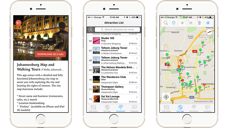 What is GPSmyCity?
GPSmyCity is a free app for iPhone or Android that says it has more than 5,500 self-guided walks and travel articles in 700 cities around the world. First, it is its own app. Then, inside of GPSmyCity you can search for cities. We obviously searched for Bordeaux, and there’s another app, “Bordeaux Maps and Walks by GPSmyCity”. Both are free, though you can upgrade the city apps like Bordeaux Maps and Walks for $4.99 and get access to additional features like location services, city maps and walking directions.
There are also user generated walks in GPSmyCity called articles. Basically, as a blogger we could sign up as a contributor and turn some of our blog posts in to self-guided walks in the GPSmyCity app. Like the walks created by GPSmyCity staff, there’s an option to upgrade the articles for $1.99 and get access to the walk with directions to each place, monument or attraction from your location using your GPS enabled smartphone.
The folks at GPSmyCity provided us with some promo codes to upgrade their Bordeaux Maps and Walks app and an article called “Bordeaux Secret Sights Tour”.
Putting GPSmyCity to the Test
We started with the Bordeaux Maps and Walks by GPSmyCity and since we’re familiar with all the regular sights, we decided to try out the Chartrons Antique Hunting Discovery Walk. Though not far from where we live in the center, Chartrons is one of the neighborhoods we’re not too familiar with.
The walk introduces itself with a brief overview of the Chartrons district. This neighborhood was formerly where the English settled when they came to Bordeaux to trade wine. There’s a few sights, but the main activity in Chartrons is to wander the lively streets and go antique shopping in the many antique shops.
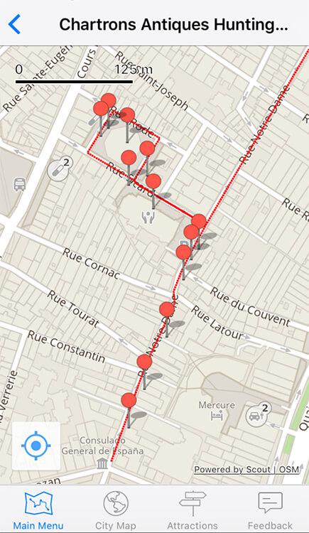
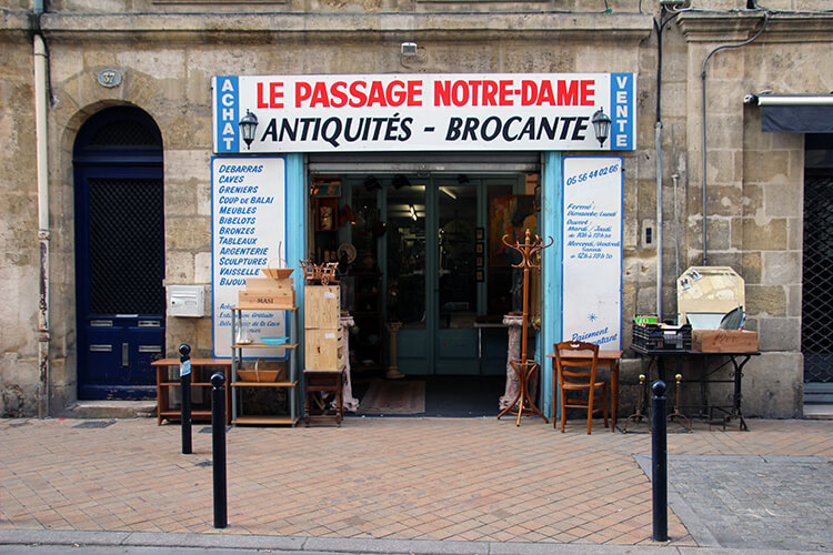
Where the Chartrons Antique Hunting walk fell a bit short is we wished that the pin pointed locations would have offered a bit more information than just an address. The shop name and hours definitely would have been helpful to know for planning a good time to do the walk as tourists might not know that most of these shops are closed on Sundays in France and many close during the day for a lunch between 12:30pm – 2pm.
Still undecided, we decided to check out part of the City Orientation Tour, included in the Bordeaux Maps and Walks by GPSmyCity. It does a good job of covering the major sites and providing a short history of each sight, though several of the walks could be combined and you might not necessarily know that unless you lived in Bordeaux. For example, the City Orientation Tour brings you to the Saint Andre Cathedral, but the Palais de Rohan which is located within seconds of the cathedral, is located in a different walk.
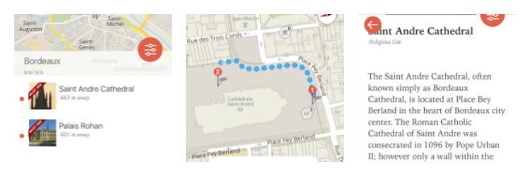
We also tried out the Bordeaux Secret Sights Tour, which is one of the tours created from a travel article by a local British blogger living in Bordeaux. It works in the same way as the Bordeaux Maps and Walks by GPSmyCity. With sights mentioned that you won’t find in a typical guidebook or a map you might pick up at the Tourist Office, the location feature was particularly helpful in navigating you right to the more obscure sights. Some, like Cour Mably, could easily be overlooked since it is a courtyard hidden through a door you might not be sure you should enter if you’re a tourist visiting Bordeaux.
The Verdict
GPSmyCity is a useful alternative to carrying around a heavy guide book and provides interesting information about a city’s sights and attractions. We also liked the travel articles, which provide information beyond your typical guidebook like more obscure sights, shops, restaurants and more. We definitely couldn’t have bought a guidebook for as little as $4.99, which is the cost to upgrade the various city apps.
As noted about the Chartrons Antique Discovery Walk, we spotted some improvements that can be made. GPSmyCity is doing a crowdfunding campaign to raise money to create what they’re calling the world’s 1st GPS-powered travel encyclopedia. Funds collected during the crowdfunding campaign will be used to double the number of cities available from 750 to 1500 and make improvements like adding an Android version of the app.
Lifetime Membership and Get 1 Free Upgrade
By pledging $60 in the crowdfunding campaign, you get a lifetime membership with access to all currently available and future walks and travel articles in GPSmyCity.
If you’d like to try GPSmyCity yourself, remember that the app is free. And you can get a free upgrade for a travel article of your choice until March 20, 2017. To get a free upgrade, contact [email protected] and mention that you’ve read about the offer here on Luxe Adventure Traveler.
We’ve been compensated to view GPSmyCity. However, Luxe Adventure Traveler maintains full editorial control of the content published on this site. As always, all thoughts, opinions, and enthusiasm for travel are entirely our own.


Jenni says
Sounds like a cool app to use whilst exploring a new city I bet I would still get lost though im not very good at map reading lol. I am going to check this out for me next trip around naples
Jennifer Dombrowski says
It’s pretty hard to get lost if you use the full map feature. It gives you step-by-step walking directions with the integrated Google Maps. You just need to have wifi or phone data. You can get the free upgrade to the full city guide for Naples. Just email [email protected] and mention you read about the app and free upgrade on Luxe Adventure Traveler.
Let us know what you think after you try it out in Naples, Jenni!
Tammy says
I have e used this app for a historic pub crawl in London and I loved it. Can’t wait to try out other walks.
Jennifer Dombrowski says
Thanks for sharing that, Tammy! It’s good to hear other feedback. I’m sure each individual walk and how it’s put together also makes a difference.
You can get the free upgrade to the full city guide for where ever you’re headed next. Just email [email protected] and mention you read about the app and free upgrade on Luxe Adventure Traveler.
Carol Colborn says
Great app functionality! If only internet prices are also good on foreign trips!
Jennifer Dombrowski says
We usually pick up a pay-as-you-go SIM card and have found them to be quite affordable. The maps are also Google Maps integrated, so the nice thing is that you can put in the walking directions when you have wifi and the dot still moves with you even if you don’t have service.
Amber says
I love the idea of being able to create your own custom walk. Very cool. And, taking one of their pre-designed walks would be great with kids in tow as sometimes tours are difficult with other people. I find the kids get bored which can irritate other people on the tour. This way we could avoid that from happening.
Claudia says
Love doing self-guided walking tours. Ones that you can customize are even more valuable and useful. This looks like a great App, shall check it out!
Jenna says
This sounds like a great app to have! It would be way more convenient than a heavy and bulky guidebook and I like that you can browse through to create your own guide if you want, as well. I love that you tried it out in a city you are so familiar with–such a great way to get a feel for how useful the guides are. Glad to hear you enjoyed it! We will have to check it out!
Christopher says
This is a great app. I personally use it as a traveller and contribute to it’s content as a travel blogger. I like that you can “relive” the trip the travel blogger wrote about by following his/her guide using the GPSmyCity’s navigation
Jestina says
Can someone help me, Based on the great reviews, I installed the app for Munich and paid extra for the maps, the monies went through my PayPal but for the life of me I can;t work out how to get my maps so that I can start planning my trip !! I even uninstalled the app and reinstalled it and NOTHING. Any help would be appreciated. I know I am doing something wrong but what, I couldn’t tell ya !! Thank you
Jane Anderson says
I got the app and designed 3 tours. I wish there was a simple edit button to revise custom walks, ie. in reverse order or omitting a stop etc. without having to make it from the beginning. But it is amazing! I’m hoping it’ll actually guide my steps so I don’t get lost.